Sunday, November 22, 2009

Whale Rider

Yeah, it's been awhile since I posted anything, but flying has been slow lately. 'Tis the season for hunkering down and anxiously awaiting next spring. I don't like it, but it does give me a chance to get caught up on other things. "What?" you may ask. "You do other things than fly?" My standard response to that comment is "Only when I have to".

I did manage to get one last 'real' flight in before resigning myself to occasional sledrides when the weather cooperates. The paragliding group was planning a trip down to the Shasta Valley in northern California to do maintenance on a flying site there. I'd never flown the site, but had driven to the top a few years ago to check out conditions. Years ago, The Whaleback, a volcanic vent that rubs shoulders with Mt. Shasta, was an often-used hang gliding site. Over the years, however, it had been used less and less, due in large part to the fact that paragliding, the more convenient 'fast food' alternative to the 'home-cooked meal' of hang gliding, saw more and more would-be footlaunchers taking short flights at their home sites on lunchbreaks rather than making the commitment of an entire day at more distant launches. When hang gliding sites are not flown, they're not maintained to facilitate that type of aircraft, and the lz at The Whaleback has over the years been overgrown and all but useless to landing hang gliders.

From the story told to me by another paraglider pilot, a pg from the local club arranged for the USFS to do the major clearing of the lz. The deal as I understand it was that if he flagged the area needed, the FS would do the major grubbing and leave it up to the pg's to do the final clearing. The pilot proceeded to flag the spot as he saw fit, but the FS actually took it upon themselves to expand the limits to where a hang glider could land there as well. I don't know if the FS person in charge was a hang pilot himself and make the site available to the pioneers as well as the fast-fooders, but I salute the USFS for accomodating those of us who require more runway.

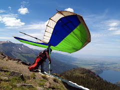
At any rate, a work party was arranged so the final clearing could be done, and maybe a flight could be taken to christen the site once again. Since the word was out that the improved lz was now hang-friendly, another local hang pilot and I decided to go check it out. Sure enough, the site looked like it would work, so after digging a few roots and raking a little brush, all two dozen para pilots and us two hangs headed up to launch to give it a go.

When we got there, we observed that the wind was a little cross from the south, but was still launchable. As Dave, the other hang pilot, and I set up our gliders, the paras all bailed off and cruised out toward the lz. Many if not most of them landed short of the mark, but that's the tradeoff for convenience I suppose. Dave and I were last off the mountain. Dave launched first and headed south to avoid the congestion of the few paragliders who were still scratching to maintain in front of launch. By the time I got off the hill, the last stragglers were gone and the traffic was clear. I launched to join Dave in front and to the left of launch where the house thermal resided. As we started to work the lift, I noticed that my drop flag had come loose and was hanging by my rear wire, so after gaining some altitude I struggled to put it back in its keeper. In the process I'd lost quite a bit of altitude, but the house thermal was still working and I gained it back.

Meanwhile, Dave had worked his way back to the face of the mountain and gained enough altitude to make a run for the other side of the valley. I lost sight of him eventually and thought he'd landed, so I headed out toward the lz. Dave's radio wasn't operating, so I radioed the lz to see if he was down yet. The response was that he hadn't, so I figured that I'd try to work back up and find him. The only problem with that idea was that I'd already seemingly committed to landing, but fortunately I found a little something over the valley and proceeded to work it back up. That 'little something' really came through, and with persistence I found myself working up the face of the volcano and soaring above the crater at around 10,000' ASL to rejoin Dave.

With the breathtaking view of Mt. Shasta a few miles to my south, I cruised the face for over an hour. It was a bit chilly up there at 10k in mid-October, but the scenery made the numb fingers worthwhile. After a couple hours in the air I finally decided to fly out and watch Dave's landing. I was still a bit tentative about the size of the lz and really wanted to watch someone else do it first. As I boated around in the light lift, I watched Dave angle across and nose in hard about halfway down the clearing. The glider didn't move, but I saw him unhook and walk away from the wing. It wasn't really encouraging to watch, and I had no way to contact him to find out what happened. I tried radioing down to the paragliders that were still hanging around, but it seems that once the last paraglider has landed, they switch off their radios and leave you to fend for yourself.

Dave's wing was still protruding a good distance into the middle of the lz, and I didn't want to try to swerve around it halfway into my approach. From the ground it probably appeared that it was clear of the lz, but from my vantage point it was an obvious hazard. I needed to tell someone on the ground to please move it out of the way, so I resorted to the only means of communication left - yelling. As I circled in a pocket of light lift over the oblivious group, I began yelling down "MOVE...THE...GLIDER!" Finally after a dozen or so yells, someone with a radio heard me and responded. Eventually the glider was moved, I set up for an approach, and brought my wing down into the lz and landed about 50' from the upwind side. Dave's glider hadn't moved because he'd broken a downtube during his hard landing and he was looking for something to splint the break so he could move it.

It was early enough in the day that a few of us decided to drive over to Herd Peak a few miles across the valley to check out conditions. I'd flown there twice, but as I remembered it, the lz was very small and hard to land in. As I set up, another pg pilot launched and cruised across the face barely maintaining altitude. Eventually I launched just as the wind was shutting down and the face was no longer soarable. The paraglider left the hill and headed down as I scratched my way across the hillside attempting to stay aloft. After a few passes I resigned myself to landing and headed for the lz. The pg had since landed and radioed that the wind had completely shut off. The two times I'd landed here, there was enough wind that I could bring my wing to a stop before running out of runway, but in no wind this would be a challenge. I fumbled with my drogue chute to increase my descent rate, but there wasn't time to get it out of its pouch and get it deployed. I came in fast and low - so much so to cause the pilot on the ground to dive for the sagebrush to avoid being hit. The approach was hot, and I used the entire lz and needed more. A few feet from the junipers at the far end I flared as hard as I could and lit in the dust, sending a cloud into the air. Unless there's some work done on this lz, I doubt I'll be landing here again...

Monday, August 24, 2009

Winding Down

Fall is fast approaching, which means that cross-country season is once again coming to a close. Last weekend, however, Ken and I were blessed with another day of XC potential at Woodrat. Ken is quickly dialing into his 'new' U2 145, and he certainly demonstrated it on Saturday with a nice out-and-back to Mt. Isabelle, seven miles out from Woodrat launch. That's the farthest we've flown together from the mountain so far. Most impressive is when Ken came in low over Raby's Peak, close enough that he could smell the pine needles, and with a bit of encouraging, pushed a little farther until he found a core that took him to 7.5k and made his flight over Isabelle a cake walk. Meanwhile, I was working some elusive lift back behind Sugarloaf before topping out at the same altitude. From there, it was a relatively easy glide across Humbug Gap to a nice climber to 7.6k over Old Blue and a continuation up the ridge toward Grants Pass. Sadly though, Old Blue was the last thermal I could find, and I had to settle for a 14-miler to Missouri Flats. Seeing Ken push his personal envelope made my day though.

Ken and I had been discussing making another trip to Lakeview while the lapse rates were still decent for that area, and the opportunity presented itself when I'd read some emails from some pilots up north who had the same idea in mind as well. I passed along the messages to Ken and we agreed upon the weekend of the 22nd & 23rd, but unfortunately a family emergency made it impossible for Ken to attend which left me to make the trip solo.

I met up with two other pilots at the campground, Scott & Casey, on Friday night, and they told me that Ray, Ron, and John were staying over at the hot springs next door. The hot springs pilots were all toting rigid wings, highly efficient gliders with a better glide ratio than our much less sophisticated flex wings. We all met up the next morning with Mark the local site guide and Mike the local hang gliding guru (who'd volunteered to drive for us) and headed up to Sugar for an attempt at Lakeview and, if possible, points beyond. The weather looked favorable, but not epic, for some cross-country flying, and we were all excited about the late-season prospects.

There were three falcon pilots on launch when we began setting up, and all three flew the ridge briefly before heading to the bailout. We were discouraged at first, but kept reminding ourselves that they were flying single-surfaced wings and were here for the first time & weren't used to the rock-n-roll ride that Sugar often delivers.

Eventually Scott, who'd also never flown the site, launched and reported that the air was big & rough - the same old Sugar I remembered - but he quickly climbed out and over the back. Casey launched next and began to climb as well. I was next, and I'd waited for a strong cycle & punched off just as it reached launch, sending me into an immediate vertical climb. I eased off to one side to allow the rigids to launch and then followed them across the face toward the lookout.

We all climbed immediately to around 11,500 and headed across Fandango Valley and toward Lakeview. I lost sight of the other wings at Fandango Peak, but the chatter on the radio was so frequent that I turned my volume low so I could hear my vario. I headed in deep over the main ridge and stayed there as long as I could to take advantage of the best lift. At New Pine Creek on the OR-CA border I headed toward the foothills to find a nice climber that took me back to 11,500. As I was climbing, I saw Casey low in the foothills below working hard to find a way up, but he eventually resigned himself to a landing at New Pine. I turned up the radio long enough to relay Casey's and my positions to Mike, but the chatter was still too distracting, so I turned it back down and continued up the range toward Lakeview.

Along the way, the lift was erratic and unorganized, and it took all my abilities to gain altitude. I did manage to gain enough to work the foothills into Lakeview, but it was still quite a stretch to make the lz. This would be my third flight to or beyond Lakeview. Scott found it equally difficult to eek out enough lift to make it over town, as did both Ron & John, but Ray found that last thermal we were all looking for - enough to get past town, on to Abert Rim and all the way to Wagontire. In contrast to Casey's 14-miler and our 25-30 mile runs, Ray went 102 miles from Sugar to the middle of the Oregon desert.

The next day started with a cloud bank over the mountains that shut out the sun until the afternoon. Strong gusts were blowing through the campground, so we all agreed that Sugar would likely be blown out. The rigid wing pilots decided to take the day off and Scott volunteered to drive for Casey & I who'd decided that with the forecast for west winds, Black Cap would be the best bet. Besides, I had to drive back to the Rogue Valley that evening and I didn't want to be too tired to make the drive safely.

We got up the mountain in time to find the sun emerging from the cloud cover and strong cycles rolling up the face. We set up and I launched first, working the face and above launch. As I began to circle I looked down in horror to see my radio dangling by the backup cord below me. Somehow it had managed to work its way out of the harness and was now on the verge of falling several hundred feet to certain destruction. I struggled to get it back into the harness and in the process lost all the altitude I'd managed to gain. By the time I had the radio secured, I was low enough that I had to leave the hill and head for the bailout lz. I wasn't pleased, but assured myself that a $200.00 radio was worth more than another flight.

I packed my gear and waited for Casey to launch next. Scott had my truck and all my gear on top of the mountain and wanted to stick around until after Casey launched, so I wasn't able to head out of town until then. So I waited - and waited - and waited. Finally I watched as Casey began his run down the shallow face, but was shocked to see his wing spin 180 degrees at the base of the slope with the nose pointed uphill. I radioed up for a status report, and Casey's shakey reply informed me that he was alright and nothing was broken. Apparently he began his run in a weak cycle and, feeling no lift on the wing, decided to 'abort' the launch. Considering that Casey has probably logged more time on a paraglider than a hang glider coupled with his later description of the circumstances, I suspect that his pg instincts kicked in and he felt that he could abort after committing to a launch. As far as I'm concerned, in hang gliding there are no 'aborted' launches - you either launch successfully or you blow the launch. An aborted launch means you changed your mind before starting your run, packed up your glider, and went home.

At any rate, Casey was alright, so all's well that ends well. But now I had to wait for Casey to break down his glider before Scott could bring my truck to me so I could leave town. It was well after 6pm by the time I was on the road, but I managed to make up enough time to be home by 9:30.

I suspect that from now toward the end of the season we'll be resigning ourselves to flying glassoffs at the Woodrat 'fishbowl', but I'm happy to have gotten in one or two final XC flights in before the end of the season. The get-together at Hat Creek is coming up in a couple of weeks, but for now it's back to instructing the fledglings...

Tuesday, August 18, 2009

Lessons

Ken and I have a great group of students going now. All three are exhibiting excellent potential, and if all goes well, we hope to have them flying at altitude before the close of the season.

Justin has been with us off and on for over a year, and now that we've got more or less regular classes, he's really starting to bring it all together. He came to us with a practically new Falcon 2 170 which he 'inherited' from a friend who left it with him to use while he is overseas. It's turned out to be an excellent trainer, and I wish we had a couple more of them to train with. After flying it down the training hill last Sunday for a little demo flight I was sold on this wing! Justin is also helping us with putting our website together and other business-related tasks.

David is a real go-getter with no fear, but at the same time he's got a good head on his shoulders. I think it's the right combination to make for a great pilot. Both Justin and David are getting very close to launching from the top of the training hill. They've had their first taste of flight and are hungry for more.


JJ started a lesson behind the other two, but he's hot on their heels. I would expect him to be working his way to the top in the next lesson.

We had another student, Krista, with whom we had high hopes. She was a dj with a couple of local radio stations. Her first lesson went very well, but unfortunately her work situation took a turn for the worse and she has to postpone for now. It's a real shame, not only because of her energy, but also because we were exchanging training for advertising, so we'll have to rely on word of mouth for now.

After a couple of false starts, things are coming together for the school, and we're anxious to get the new fledglings in the air with us soon.

Sunday, August 9, 2009

Ketchup - Part 2

Fishbowl Flying in the Applegate
A few screenshots of recent flightlogs

7/23/09 - Just a fun little glassoff, screaming past the paragliders and going where they couldn't...


7/26/09 - Another glassoff - same scenario


8/1/09 - A 2-hour tour. The weather started getting rough - the tiny wing was tossed (sung to the tune of the Gilligan's Island theme).


Across the valley I worked up to cloudbase at 8,000 in very aggressive lift. Wires went slack a few times, and I came as close as I care to looping in a strong core. I landed just before the clouds covered the sky and the thunderboomers started. It looked pretty benign not long before that, but from the beneath a cloud it's hard to tell how tall it really is. I was glad to be on the ground...

8/8/09 - Wind from all directions at various altitudes. The smokey inversion kept everyone from getting above 6,000, but across the valley I managed to punch through and get to 7,800 in front of Wellington Butte. From there, it was an easy glide to Tallowbox to explore some new areas of the fishbowl.


More 'fishbowling' with our buddies from Eureka, CA. Much to my chagrin and after a big buildup, Raby's Ridge just wasn't working today. Eating crow is difficult - first you gotta catch one! Sorry guys - maybe next time. We'll be down to fly Funston with you...

Sunday, August 2, 2009

Ketchup Part 1

It's been an eventful few weeks and I'm getting behind on my blogging, so it's time for some ketchup.

PART 1 - ROADTRIP

To start out, it was Juli's birthday on the 17th of July, and for her big day she wanted a road trip. I made a detour through Joseph, John Day, and Bend on my way back to Grants Pass from Sandpoint awhile back, and I told her how beautiful the drive was, so she decided that's where she wanted to go. I negotiated a few days off to make the trip, and thankfully my supervisor generously cooperated. I have to admit though that I was a bit selfish in making these plans. Two sites that I'd always wanted to fly just happened to lie along the route, one being Pine Mtn. near Bend and the other being Mt. Howard in Joseph.

Bend was the site from which the Oregon State cross-country record had been set (163 miles by Mike Tingy) , so I had high expectations. Unfortunately, high expectations often lead to high disappointments. The day before, Patrick Kruse, the local site orienteer reported that pilots had been getting up to 15,000-plus - a great start for a long XC flight. When I met up with Patrick, Scott, Joe our driver, and Chuck, however, the wind was switchy with a dominant north direction. The launch faces west, so that meant we'd have to wait for a reasonable cycle (at least 45 degrees from straight up the face) to launch.

Meanwhile, on the way up the mountain we came to a van that had driven partially off the narrow, steep road and was blocking the way to launch. A pickup belonging to paraglider pilots was parked about 100 yards below, and we'd heard that they'd hiked on up to launch, telling the occupants of the van that some hang gliders were on their way and would help out since we couldn't pass otherwise. So much for comraderie. We did help out and got the van back on the road, but in the process, another van belonging to a separate group of paragliders backed into the passenger door of my pickup. The driver was very upset & apologetic and gave me her number so we could coordinate repairs.

The flight wasn't anything to write home about. We each picked the best cycle we could find, and although the first two pilots managed to gain over 1,000', I launched into the downcycle and we all headed down to the bailout together. I landed first, flaring over the knee-high sagebrush for a no-stepper, and Scott followed with a not-so-pretty no-winder that resulted in a hard landing, destroying his control frame. Patrick followed next with a fast, hard flaring finish and both feet on the ground. Chuck launched after all of us and climbed to 12,000-plus for a nice out-and-back on his rigid wing. Timing is everything in this sport, and ours was just a bit off...

From Pine, we headed across the badlands of Oregon to the painted hills and Mitchell, where we booked a room in a historic hotel in this 'Twilight Zone' of a town. I won't go into the details of our 'adventure' here, except to say avoid room #10. In fact, avoid the hotel entirely - it's managed by a woman who would obviously rather be elsewhere if her dad wasn't running the gas station across the street and she didn't have two loud, obnoxious children tying her down to this spot. Henry the bear, who is caged at the gas station, also appeared to want to be elsewhere. So did we, and we left early the next day, stopping in John Day to tour a chinese heritage center (well worth the visit).

The highlight of the trip was Joseph, a beautiful little artist's community at the base of the Eagle Cap Wilderness. Joseph was named for Chief Joseph, the Nez Pierce leader who evaded the U.S. Cavalry led by General Howard in the mid-1800's. Howard was sent to round up Joseph's people and deliver them to a reservation in Idaho, but Joseph (originally named Thunder-Rolling-Down-The-Mountain) was a skilled tactician and eluded the cavalry for many miles, finally surrendering with his band of remaining warriors, elderly and children just a few miles from the Canadian border and freedom.

Joseph is a beautiful little town skirted to the south by the Wallowa Mountains, including Mount Howard. The top of Howard is accessed by tram, and here among the peaks towering 4,000' above the valley floor is where I hoped to fly from. This site and Glacier Point in Yosemite are the two main reasons I'd attained my advanced hang glider rating, which is required to fly both sites. Dr. Philip Stonebrook, the official site orienteer, was an old friend of mine. He and his wife, Jodie, had moved here from the Rogue Valley, and I had flown with Philip several times when I first got into this sport. Our plan was to pitch a tent in a nearby campground and visit the Stonebrooks, but Philip insisted that we stay at their place, enjoying the generosity of their comfortable accomodations, amazing meals and fine company. A good friend of theirs, Bob, was visiting from Ashland and insisted on buying us all dinner (Juli's birthday dinner) at the local pub. We gratefully accepted.
The next day Philip and I scouted out the bailout lz to Mount Howard as well as the alternate (and preferred) lz near his house several miles from the mountain. Then Philip, Jodie, Juli and I loaded my gear and headed for the park at the far side of Wallowa Lake where the tram departed for the top of the mountain. Some years ago Philip had created a system for attaching gliders to gondola cars to transport to the top, and it worked great. After a scenic trip up the tram we were at the top of Mt. Howard. We packed my wing and harness the 1/4 mile or so down the trail and I began my setup procedure as a small crowd gathered near launch. After assembly was complete, I climbed into my harness, carried the glider to launch, and awaited a good cycle while taking in the view of the lake and valley below and mountains to either side.

When a straight sustained cycle rolled up the face I launched to the cheers of the croud and headed out to where Philip told me I'd find the resident thermal. Sure enough it was where he said, and I began climbing slowly to about 9,500'. It was a weak core and eventually I topped it out, so I headed back out front to try to find another one. I'd dropped well below launch before heading back to where I'd first found lift. Fortunately, a hawk was working some lift in front of the hill, so I joined him, this time to find a strong core that took me to around 11,500'. At this point I was high enough that I could see deep into the wilderness behind launch and the mountain peaks that seemed to go on forever to the south. Deep blue mountain lakes were now visible, as were snow covered cirques and craggy peaks. What an incredible view!

After topping out, I radioed down that I was heading across the lake and over to Chief Joseph Mtn., a long steep ridge that continued several miles to the west. My hope was to work my way to the top of the ridge where more thermals would be found, but the best I could do was work to within a few hundred feet of the top. I managed to glide the entire length of the ridge, however, and well beyond the lz near Philip's house, so after working the foothills below the face while the clouds shut off the lift, I headed to the big field out front, dropped my wind flag, and set up for a nice smooth landing. Juli and Philip soon showed up to help load the gear, and we returned to enjoy more of Philip and Jodie's hospitality. The flight lasted about an hour and forty-five minutes, and I was in awe of the amazing scenery for most of it. I will definitely be back for more!

Monday, July 6, 2009

Lakeview '09

From the reports I’d read, Woodrat was experiencing some uncharacteristically high lift. The baggies were bragging about climbs above 13,000 ft. ASL, while normally the highest one could expect to get was short of 10,000. Despite these reports of freakish conditions, I’m glad I went to Lakeview instead. Lakeview conditions typically make Woodrat seem like a cross-country training site with the potential for some ‘fishbowl flying’, but no huge distance potential. As usual, and despite the unusually high lift in the Rogue Valley, Lakeview was the place to be.

The first couple of flights weren’t very exciting for me. I was hoping to leave Sugar Hill and at least make it to Lakeview, but the lift there is squirrelly and the best I could get was about 8,000 ft. ASL – not enough for a comfortable cross-country flight. There were some personal-best flights logged from a friend, however. The first one resulted in a climb to 16.8k and a land-out halfway between Fort Bidwell and Adel which by my estimation would be about a 20-mile flight. The second took him from Sugar to 13 miles north of Lakeview – around 35 miles overall. There were many similarly long and high flights by others as well.

My third flight on July 4th wasn’t a record-breaker for me, but it did take me to a place I’d always wanted to fly. Abert Rim, rising 2,500 ft. off the valley floor and extending for 30 miles into the Oregon desert, is the largest fault escarpment in North America. Abutting the north base of the rim is 15-mile-long Abert Lake which is separated from the rim by the narrow ribbon of land just wide enough for Highway 395 to wind its way toward Burns, Oregon. The shear vertical face of the rim dominates the landscape as one drives north of Lakeview, and its magnificence transcends description. I’d heard stories about its spectacular beauty from hang glider pilots who had been blessed with the opportunity to soar its heights, and I’d hoped that one day I too would share the experience. The opportunity appropriately presented itself on Independence Day.

Ken and I went to the top of Black Cap, the launch overlooking Lakeview, with the intention of competing in the spot-landing contest scheduled for that day. With a couple of exceptions, it appeared that the conditions were marginally soarable, so the best we’d hoped for was a sled ride to the landing target and maybe another try later on. One of the exceptions was a semi-local pilot named Jimmy who would launch in his customary way, skimming the ground just high enough to produce gasps from the spectators and flying to the next ridge to find a decently consistent thermal. From there he would climb up to about 8,500’, fly back over launch, and strafe the crowd for a few more gasps before returning to the thermal and repeating the process. We’d both agreed that after launching we would follow his example and head directly across to the point where his thermal originated, which we’d begun referring to as Jimmy’s Boomer, with the hope of extending our flights and maybe getting a bit more airtime in before going for the spot. Anticipating a short flight, I’d decided to leave my drop flag behind and stow my gloves in my harness. As I did so, I commented to Ken that this was a sure way to guarantee a long and high flight. Duration and altitude always seem to be inversely proportional to expectation and preparation.

Ken launched first in a nice cycle, and after clearing the hill he’d started working a thermal out front for a gain of a couple hundred feet. Sticking to our intended plan, he headed across to Jimmy’s Boomer and began hunting for the core. A few minutes later, I launched in a light cycle which resulted in a launch not dissimilar to Jimmy’s – a bit too close to the shallow slope for my comfort – and headed across in mostly sinky air. I did get a slight boost on the way to the boomer, but decided not to stay and work it. As I reached the adjacent hillside and began hunting around, Ken radioed that he couldn’t find the lift and was getting low. Meanwhile, I’d found some workable lift and began circling. As I allowed the glider to drift downwind with each circuit I felt the core gain in strength until it turned into a nice solid climber – I’d found Jimmy’s Boomer.

I continued to work the thermal for several circuits, occasionally adjusting my course to stay with the core. Instead of topping out at 8,500’, however, this time it kept rising almost to 13,000’ before beginning to dissipate. On the way up I radioed my progressive altitude to Ken who had since landed in the bailout field, and Marti & Juli who were driving our retrieval truck. With this much altitude, a cross-country flight was a must, and the only question was which way to go. I looked toward Adel twenty-odd miles to the east and Abert Rim whose unmistakable features dominated the skyline about 17 miles to the north. I’d made the flight toward Adel at the nationals last year but had never ventured any farther north than Highway 140, so the choice was clear – the rim was my goal. I leveled off, pulled my VG tight with my frozen ungloved hand, turned for the mountains deep behind Lakeview, and radioed to Marti that I was headed for Abert Rim. "I don't know where that is", she responded. "Just head north", I replied. This was to be our final conversation until after I landed.

The first eight miles along my course was heavily forested with no landing zones within normal glide, but fortunately I was flying in air relatively free of sink and reached the hills at around 8,000’ AGL. Reading the terrain, I located a second thermal 10 miles out and worked it back up another thousand feet or so. From here I could work the ridges and maintain altitude fairly easily until I reached the south end of the rim. There was only one point where I began to sweat – a relatively sinky stretch that extended a mile or so toward the valley that had me questioning my ability to glide upwind to a safe landing field, but I soon found more lift and milked it sufficiently to reach the rim. I flew about 500’ over Tagues Butte, the customary launch for soaring the rim, and from there had no trouble reaching the 30-mile-long escarpment.

Once I was alongside the sheer rock face of the rim, I relaxed and began enjoying the beauty of the valley to my left and the features of the yellow lichen-encrusted sculptural rock to my right. As I reached each spur of scree at the base of the wall, I would gain a boost of lift sufficient to allow a glimpse of the vast flat plain that extended as far as the eye could see behind the rock ledge. The beauty of the landscape sincerely defies description, and in hindsight I really wish I’d had a camera in my harness, although photos would not have even begun to do justice to the experience. It was like ascending from one world to another reminiscent of Philip José Farmer’s World of Tiers, and I was Kickaha.

About two miles past Tagues I found a spot of lift emanating from a chasm in the rock face that seemed worth working, so I began to circling lazily in a steady climb until I emerged above the cliff edge and ascended above the upper plain of the escarpment. The lift coalesced into a strong core, and as I continued to circle I noted a huge shadow on the plain below and downwind of me. I was now working my way to the base of a well-formed cumulus cloud while looking down upon the two worlds. While circling, I caught a brief radio transmission that sounded like someone saying ‘Hog, are you there?’ (I’ve been branded with the name Airhog, and Ken often addresses me as such, even though he has since bettered me in the time-aloft department). I tried responding, but couldn’t tell if my transmission was received. At the off-hand chance that I could be heard I began blathering excitedly at the view I was being blessed with. Ultimately I was never heard, although expressing my observations verbally somehow seemed to heighten the experience.

I continued my circuits and came to the realization that once I reached cloud base I had another decision to make. Should I continue north up the rim beyond where the lake began, or should I leave the rim and head west into the valley and toward the town of Paisley? The rim would probably generate continual lift, but the lake was fifteen miles long and practically abutted the base of the escarpment leaving little or no area to land. I’d never driven the highway between the lake and the rim and had no idea what landing opportunities were there, but it looked pretty tight from my vantage point at cloud base. I’d really hate to spoil such a beautiful flight with a water landing, or be forced to land on the highway and risk becoming a hood ornament for a semi. The deciding factor was a short cloud street (more like a cul-de-sac) that extended a brief distance to the west. I once again tightened the VG and went on glide over the valley.

From 10,000’, the sage brush looks mighty small and it’s really hard to tell how big those green clumps really are, but experience has taught me that if you can see individual clumps from the air, it’s probably not a good place to land. The only alternative was a stretch of alkali flats sparsely dotted with clumps of brush. Some areas appeared to glisten with moisture, but others had discernable tire tracks. This would be my targeted landing zone. I reached the end of the cloud street and began my descent. As I was on final approach I heard a strong transmission from a distant paraglider pilot, so I responded and requested a relay to Marti. He tried twice but received no response. I thanked him for trying, identified myself and described my location in case my retrieval plans fell through. While on final, I noted the pattern of wind lines on the nearby bodies of water, so at least I had an idea of the wind direction. Just in case I was wrong, I fished my drogue chute from my harness to ensure that I had an adequately high descent rate to prevent overshooting the target. All went smoothly and I gently descended onto a clearing in the dry mud flat, flaring into a light headwind.

After unhooking, crawling out of my harness and shutting down my instruments I called Juli, Marti, and Ken’s cell phones to relay my approximate location. Reception was spotty, so all I could do was leave messages. Before beginning to break down my glider I took a look around at my surroundings, and it dawned on me just how vast this part of Oregon really is. The hard white fractured mud beneath my feet spread in all directions, yielding frequently to large clumps of sagebrush. Occasionally a jackrabbit would dart from the shade of one clump to the cover of the next. Off in the distance was the endless saffron face of Abert Rim, and in all other directions the horizon was punctuated by multicolored scarps of various sizes, the low sun angle casting mauve shadows across their crevassed faces. I’ve always felt more at home in greener, more mountainous terrain, but I couldn’t deny how beautiful this alien countryside was that now surrounded me. Beautiful but lonely. It occurred to me that I could quite possibly have landed somewhere truly remote and have to spend the night out here with just the water in my camelback and my harness to sleep in. I didn’t bring matches or provisions of any kind, and I was lucky that my landing went well and I wasn’t injured. The road was only a quarter mile or so to my south, as the occasional passing car reminded me, but that would have been a long crawl had I broken a leg.

At the peak of my survivalist fantasy, the piercing ring of my cell phone brought my thoughts back to civilization. I’ve always disliked cell phones (the banner of mine reads ‘damn phone’), but at this instant it sounded heavenly! Better yet was the voice coming through the speaker. It was Juli, my sweetie, coming to rescue me from the lonely heat of the desert! So good to hear her laughing voice, even though the weak reception cut her off mid-sentence. I finished packing my gear and hiked to the highway a few hundred yards away to find the pickup alongside the road a short distance away. Perfect timing! What a team! We loaded my harness & glider and headed back to Lakeview to catch the end of the barbecue.

The flight was only an hour and a half in duration and several miles short of my best cross-country so far, but it was one of the most unforgettably beautiful flights I’ve ever had in the six short years I’ve been flying. The only downside is that I missed the spot-landing target – by twenty-six miles!

Wednesday, July 1, 2009

Big Air for the Fourth


The lapse rates are looking pretty nice for the Umpteenth Annual Festival of Free-Flight in Lakeview, Oregon that starts tomorrow. In fact, they're looking very similar to the way they did at last year's national competition where I had my two best flights ever, including an amazing single climb to 16,500' asl. We'll be headed east for the high desert for the country known as the Oregon Outback this afternoon. I'm bringing my didgeridoo along so I can conjure up some big air..and maybe one of those extremely rare Oregon kangas.